1/18


VFRnav – Flight Navigation
1K+下载次数
50MB大小
4.13.2(24-06-2025)最新版本
详情评价版本信息
1/18
VFRnav – Flight Navigation介绍
VFRnav 是一款导航应用程序,专为满足目视飞行规则 (VFR) 下飞行的飞行员的需求而设计。该应用程序将国际民航组织风格的移动地图与全面的规划和记录功能相结合,实现可靠、高效的飞行导航。
主要特点:
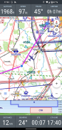
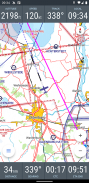
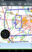
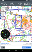
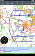
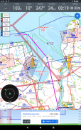
• 基于地图的导航:在 ICAO 风格的地图上显示飞行路线,并提供实时位置更新。
• 离线操作:设置后可离线使用所有功能;飞行期间无需有效的互联网连接。
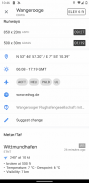
• 数据库:有关众多欧洲国家的机场、航路点和导航设备的综合信息。
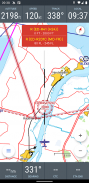
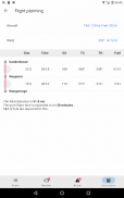
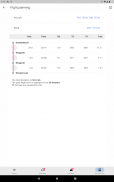
• 飞行规划:协助航线规划、燃油计算和飞行时间估算。自动集成规划路线的天气数据和航行通告。
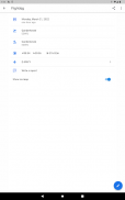
• 数字飞行日志:自动记录起飞和着陆时间。将航班数据导出为 KML 文件,以便在 Google 地图等应用程序中使用。
• 外部传感器:支持通过 WiFi 或蓝牙与外部 GPS 接收器和交通数据源(例如 FLARM、Stratux、CCAS、SafeSky、ADS-B)集成。
技术要求:
• Android 版本5 或更高版本。
• 最小屏幕分辨率为480x800 像素。
• 至少200 MB 的可用存储空间。
许可模式:
VFRnav 在购买前可以不受限制地进行全面测试。许可证费用为 49.95 欧元,并提供一年的免费更新。初始期限过后,可以续订更新期限。无论更新如何,该应用程序仍保持完整功能。许可证是个人许可证,对链接到同一 Google 帐户的最多三台 Android 设备有效。注意:Android 设备的许可证并不授予 Apple 设备的使用权。
免责声明:
无法保证所提供信息的准确性和完整性。使用风险由您自行承担。应用程序中显示的数据应始终根据官方航空图表进行验证。
VFRnav – Flight Navigation - APK信息
APK版本: 4.13.2程序包: com.flugbetrieb.VFRnav名称: VFRnav – Flight Navigation大小: 50 MB下载次数: 0版本: 4.13.2发布日期: 2025-06-24 13:00:10最小屏幕: SMALL支持的CPU:
程序包ID: com.flugbetrieb.VFRnavSHA1签名: 95:96:EB:D0:85:40:5D:CA:87:30:7C:1E:3F:12:2B:D3:A4:9D:94:36开发商 (CN): Hermann H?lter组织 (O): flugbetrieb.com本地 (L): 国家/地区 (C): 州/市 (ST): 程序包ID: com.flugbetrieb.VFRnavSHA1签名: 95:96:EB:D0:85:40:5D:CA:87:30:7C:1E:3F:12:2B:D3:A4:9D:94:36开发商 (CN): Hermann H?lter组织 (O): flugbetrieb.com本地 (L): 国家/地区 (C): 州/市 (ST):
VFRnav – Flight Navigation的最新版本
4.13.2
24/6/20250 下载次数9 MB 大小
其他版本
4.13.0
17/6/20250 下载次数9 MB 大小
4.12.3
1/6/20250 下载次数9 MB 大小
4.12.2
30/5/20250 下载次数9 MB 大小
4.12.1
24/5/20250 下载次数9 MB 大小
4.11.0
7/5/20250 下载次数9.5 MB 大小
4.10.3
3/5/20250 下载次数9 MB 大小
4.10.0
30/4/20250 下载次数9 MB 大小


同类应用


English


